How the Flyability ELIOS 3 navigates precisely in completely dark, GPS-denied interiors. SLAM (Simultaneous Localization and Mapping) enables the drone to operate safely inside tanks, boilers and chimneys – without any satellite signal.
Every standard outdoor drone (DJI, Autel etc.) uses GPS/GNSS for position determination. This works reliably in open-air environments – but what about inside industrial facilities?
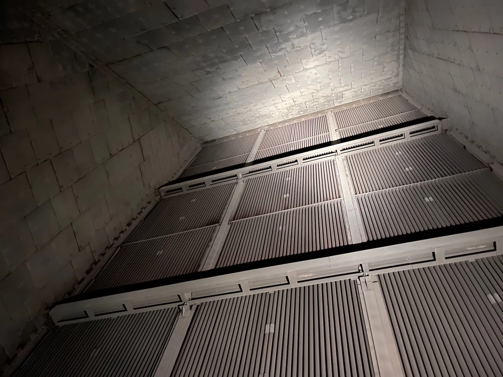
Inside a tank, boiler or chimney there is no GPS signal.
No GPS means: the drone does not know where it is. It cannot hold position, cannot maintain stable hover and cannot navigate autonomously. Sending a GPS-dependent drone into a confined space is simply not an option.
This is precisely the problem the Flyability ELIOS 3 was designed to solve. It uses SLAM (Simultaneous Localization and Mapping) – a navigation method that works entirely without GPS. The drone maps its surroundings in real time and determines its position from the geometry of the space.
SLAM is an algorithm that solves two tasks simultaneously:
The special challenge: both tasks depend on each other. To know where you are, you need a map. To build a map, you need to know where you are. SLAM solves this chicken-and-egg problem iteratively in real time.
Simplified:
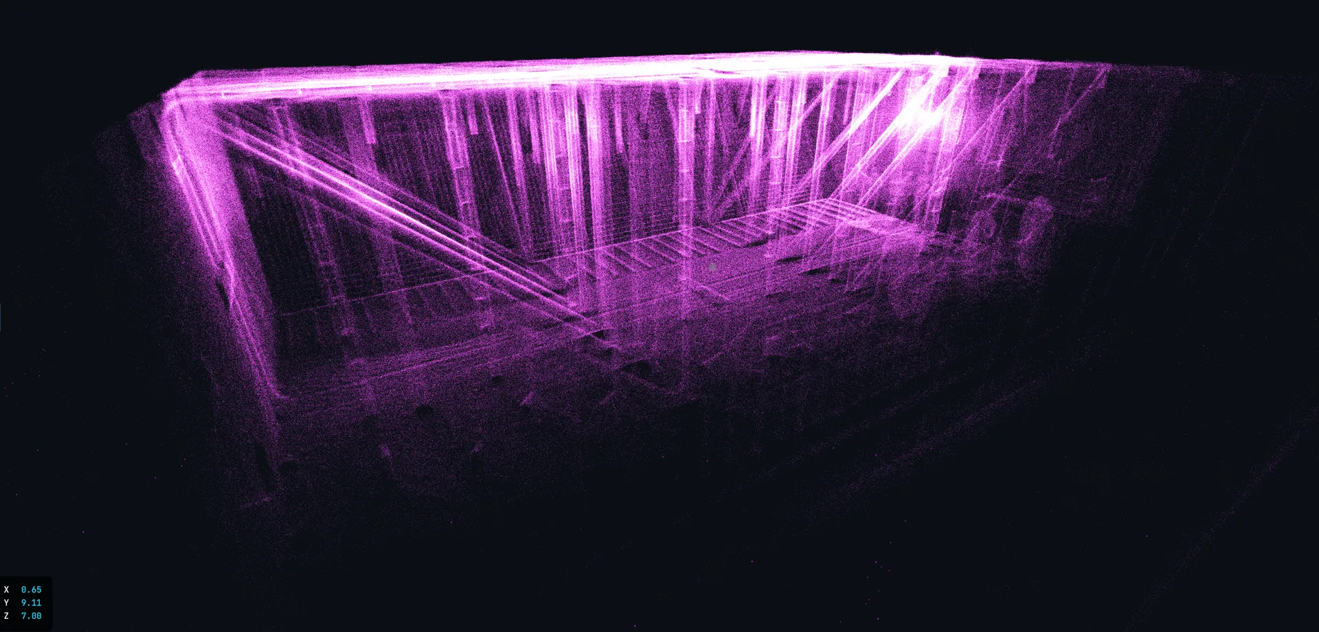
The drone fires millions of laser points in all directions from its LiDAR sensor. These points create a 3D map of the surroundings. Simultaneously, the drone compares what it currently sees with what it has already seen – and derives its current position from this comparison.
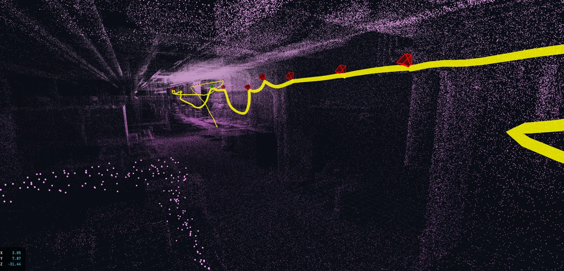
In practice: The ELIOS 3 creates a real-time 3D map (live map) on the pilot controller during flight. The pilot can see at all times where the drone is and which areas have already been covered.
SLAM comes in different variants – not all are suitable for industrial environments. The FlyAware™ Engine by Flyability is specifically optimised for the requirements of confined spaces (Confined Spaces):
Uses the Ouster OS0-128 LiDAR sensor instead of cameras. Works independent of light and surface texture – even in completely dark spaces.
FlyAware combines LiDAR, IMU (Inertial Measurement Unit) and computer vision on an NVIDIA processor. The different sensors mutually compensate for each other's weaknesses.
The 3D map is not calculated after the flight but in real time. The pilot immediately sees where the drone is and which areas have been covered.
The ELIOS 3 regularly collides with walls and fittings – and keeps flying. The FlyAware Engine maintains orientation even after collisions.
During long flights in large structures, SLAM can drift minimally. FlyAware minimises this drift through continuous comparison with already mapped areas.
The ELIOS 3 pilot has three information sources on the controller:
The standard camera image in real time – as with any FPV drone. The 16,000 lumen LED illumination makes even completely dark spaces visible.
The key innovation: a three-dimensional map that grows in real time. The pilot sees the 3D geometry, the drone position and already covered vs. not yet captured areas.
Flight time, battery level, distance to entry point and sensor status – all critical information at a glance.
One of the most important functions that SLAM enables: Smart Return-to-Home.
The problem: When the battery runs low inside a winding confined space, the drone must find its way back to the manhole – through narrow passages, around fittings, through multiple levels.
The solution: Since the ELIOS 3 has created a complete 3D map of the space via SLAM, it knows the way back. Smart Return-to-Home navigates the drone automatically along the flown path back to the entry point.
Since 2025/2026: This function has been significantly improved. The drone optimises the return route and avoids obstacles detected after the outbound flight.
Why this matters: A drone loss inside a confined space is not only costly (hardware), it can delay the entire inspection operation – especially if the drone gets stuck in a location that is difficult to access. Smart Return-to-Home minimises this risk.
GPS/GNSS
Standard for outdoor drones. Accuracy: 1–5 m. Indoors: not available.
Visual SLAM (camera-based)
Uses camera images to recognise features in the environment and derive position. Problem: only works with sufficient light and textured surfaces – bare metal walls, darkness or dust put the system out of action. Not suitable for industrial confined spaces.
LiDAR-SLAM (ELIOS 3 / FlyAware)
Uses laser points instead of camera images. Works light-independently and texture-independently. Mapping precision of the Ouster OS0-128: ±3 cm. Ideal for dark, dusty, structure-poor industrial environments.
Ultrasound/ToF sensors
Simple distance measurement (obstacle detection). No complete 3D mapping. Only usable as a supplement, not as the primary navigation system.
Tether-based (cable)
The ELIOS 3 has offered an optional tether solution since 2025: a physical connection to the drone for unlimited flight time and data transmission. SLAM remains the primary navigation system – the tether supplements it with power supply.
| Criterion | GPS/GNSS | Visual SLAM | LiDAR-SLAM (ELIOS 3) | Ultrasound/ToF |
|---|---|---|---|---|
| Indoor use | ✗ | ⚠ Limited | ✓ | ⚠ Obstacle detection only |
| Darkness | ✓ | ✗ | ✓ | ✓ |
| Textureless surfaces | ✓ | ✗ | ✓ | ✓ |
| 3D mapping | ✗ | ⚠ Limited | ✓ (1.31M pts/s) | ✗ |
| Precision / mapping | 1–5 m | Variable, unreliable in industrial environments | ±3 cm (LiDAR mapping) | cm–dm depending on sensor |
| Dust/vapour tolerance | ✓ | ✗ | ⚠ Reduced | ✓ |
| Suitable for confined spaces | ✗ | ✗ | ✓ | ✗ |
SLAM is impressive – but not perfect. These limits are worth knowing:
In extremely large spaces (e.g. natural draught cooling towers > 100 m), the SLAM algorithm can drift minimally. Navigation remains stable, but the point cloud becomes slightly less accurate at the margins.
SLAM needs geometric features. In completely round, smooth tanks without any structure, the algorithm has fewer anchor points – in practice rarely a problem thanks to weld seams and internal fittings.
Dense dust or vapour can scatter LiDAR beams. The ELIOS 3 is deployed in cleaned/gas-freed confined spaces – residual dust is not a problem, but active steam discharge is.
The ELIOS 3 is specified for a maximum ambient temperature of 50°C. Deployment in actively fired plant is not possible.
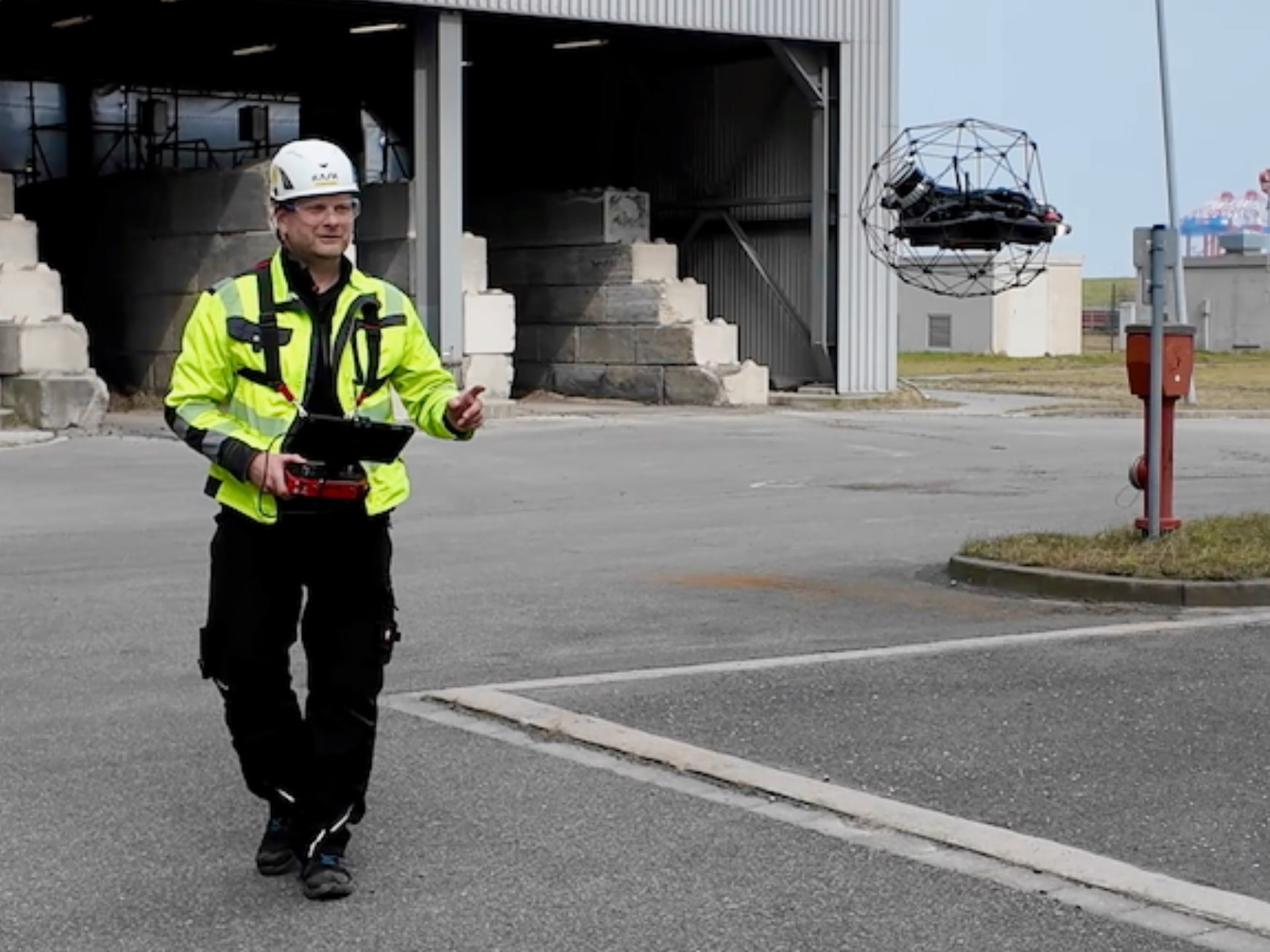
Our pilot team has been flying the ELIOS 3 in confined spaces since 2017 – in tanks, boilers, chimneys, silos and complex industrial structures.
 Christian Engelke
Founder & Drone Pilot
Christian Engelke
Founder & Drone Pilot Karsten Lehrke
Managing Director
Karsten Lehrke
Managing Director Philipp
Drone Pilot
Philipp
Drone Pilot Max
Inspection Specialist
Max
Inspection Specialist Benjamin
Drone Pilot
Benjamin
Drone PilotYes – in calm conditions this is possible. We fly the ELIOS 3 outdoors as well, e.g. on external walls or pipe racks, up to approximately 10–15 m height. The limiting factor is not SLAM (the drone finds sufficient geometric references outdoors), but wind: the protective cage of the ELIOS 3 provides no aerodynamic stability under wind loading. Once wind is involved, the drone is not safely deployable outdoors. For wind-exposed external inspections we therefore use other drone types.
The Ouster OS0-128 LiDAR of the ELIOS 3 achieves a mapping precision of ±3 cm. This means: the 3D point clouds and measurements derived from the scan are highly precise and directly usable for damage assessment and maintenance planning. The navigation position-holding is designed for safe flight and systematic coverage in confined spaces.
Yes. Flying the ELIOS 3 in confined spaces requires experience and training – both in handling the protective cage (collision management) and in interpreting the live map. Our pilot team has years of experience and has completed numerous confined space deployments.
The ELIOS 3 is manually controllable. Even in the event of a SLAM failure, the pilot can safely fly the drone back to the entry point using the camera image and the control sticks. The protective cage prevents damage on contact with walls and fittings.
No. LiDAR does not work underwater (laser scattering). For underwater inspections we use ROV systems with other navigation methods (sonar, visual referencing). The ELIOS 3 is designed exclusively for aerial operations.
We are happy to explain how the drone navigates in your specific application. Send us your plant data – we will respond with a feasibility assessment.
Kopterflug Inspection Services GmbH
Am Tabakquartier 62, 28197 Bremen, Germany
+49 421 408 937-0 ·
[email protected]
Source page: /en/knowledge-base/slam-navigation-drohne