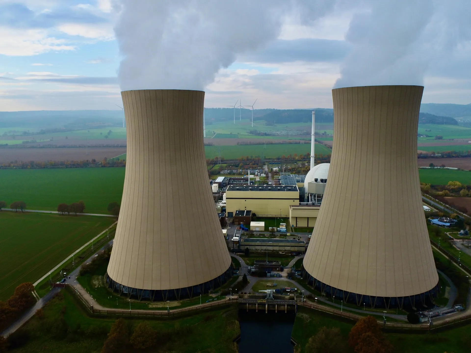
Kopterflug deploys the Flyability ELIOS 3 for drone inspection in nuclear facilities – reactor buildings, containment structures, cooling systems, ventilation ducts and decommissioning sites. No personnel entry into contaminated areas. ALARA in practice, not just in principle.
Nuclear facilities place the highest demands on safety and documentation. We inspect critical areas – without human entry, ALARA-compliant:
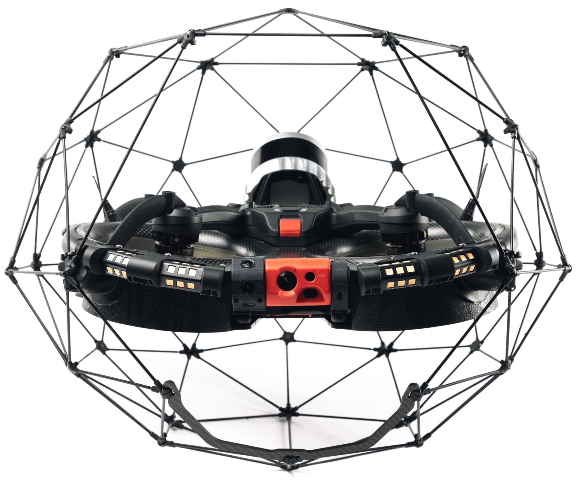
The ELIOS 3 with its collision-safe carbon cage – designed for confined and contaminated industrial environments.
ALARA – As Low As Reasonably Achievable – is the guiding principle of radiation protection. Drone inspection translates this principle into operational practice:
Over 30 nuclear facilities in Germany are currently in decommissioning. Each requires extensive condition documentation before dismantling work can begin. Drone inspection delivers this data – systematically, reproducibly, and without personnel entering contaminated zones.
Contaminated areas, radiation exposure, strict approval procedures. Every inspection involving human entry increases the collective dose. The ELIOS 3 documents without human entry.
Depending on the facility and inspection objective, we deploy the ELIOS 3, RAD sensor or ROV – ALARA-compliant, without human entry into controlled areas.
With the Flyability ELIOS 3, we document nuclear facilities without human entry – ALARA-compliant, precise, with the data needed for decommissioning and approval:
Condition survey of building structures, installations and pipelines for decommissioning planning. 4K video and LiDAR-3D provide the basis for tendering and approval procedures – without human entry into contaminated areas.
Condition inspection of ventilation ducts, cable trays and pipe tunnels in contaminated building areas. 4K video and LiDAR-3D capture geometry and damage patterns – as a basis for decontamination concepts and dismantling planning.
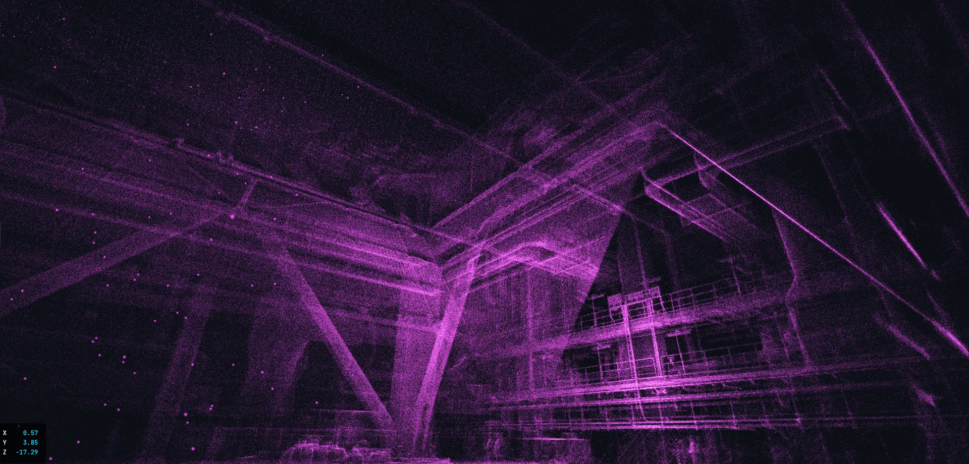
Condition documentation of containment structures, concrete surfaces and installations. LiDAR captures geometry for digital twins and dismantling planning.
Steam generators, condensers, cooling water lines – visual inspection and 3D documentation of hard-to-access cooling circuit components.
3D radiation map through spatially referenced dose rate measurements during flight. Exposed zones are visualised, access areas planned in a targeted manner – ALARA concept on a data basis.
Inspect spent fuel pools and water-filled wet storage without draining and without divers – ROV inspection with 4K camera. Fully document pool linings, floor and storage structures. Personnel dose = zero.
Inspection of cells with high contamination or radiation – classic no-go zones for personnel. One of the most valuable ALARA use cases: zero personnel dose through complete replacement of the walk-through.
Inspection of underground cable ducts, cable cellars and utility passages – often contaminated, poorly accessible and incompletely documented. Extremely relevant for decommissioning planning and dismantling sequences.
Drone inspections in nuclear facilities do not replace expert assessments by certified inspection bodies – they deliver the data basis: systematic, reproducible and without human entry into contaminated areas. ALARA in practice.
| Area | What We Check | Why It Matters |
|---|---|---|
| Ventilation Ducts & Pipe Tunnels | Duct wall condition, connecting flanges, fire dampers, deposits, crack patterns, contamination evidence (visual) | Classic confined spaces – DGUV inspection would mean dose burden for the inspection team. ELIOS 3 traverses the full duct length and documents completely, without human entry. |
| Containment & Reactor Building | Concrete surface (cracks, spalling, carbonation), coating condition, embedded parts, pipe penetrations, anchor points | Containment buildings must remain structurally intact even during decommissioning. Concrete damage is quantifiable via LiDAR comparison measurements – basis for decommissioning decisions and approval documents. |
| Cooling Systems, Pipelines & Heat Exchangers | Pipeline corrosion, leak traces, insulation condition, thermography for thermal anomalies | Residual cooling water and radioactive media in pipelines represent a contamination risk during decommissioning. Drones deliver condition data for decommissioning planning without direct personnel contact with potentially contaminated surfaces. |
| Shafts, Spent Fuel Pool Surroundings & Vertical Structures | Concrete condition in shafts, reinforcement corrosion, installations, cable trays and brackets | Deep shafts are practically inaccessible for personnel without extensive safety measures. ELIOS 3 flies vertically into the shaft and documents completely – without fall protection for personnel. |
| Decommissioning Documentation: Rooms & Plant Components | Complete room survey for decommissioning planning: geometry, inventory (visual), surface condition, decontamination level | Decommissioning approvals under AtG require precise condition documentation – often per room and component. Classic walk-throughs in contaminated areas are cost-intensive and dose-burdening. 3D models replace numerous individual walk-throughs. |
Result: 4K inspection report, LiDAR-3D model and thermography evaluation – prepared as a data basis for your certified inspection body, decommissioning planning and approval procedures. We coordinate the deployment and safety protocol in advance with your radiation protection officer.
The ELIOS 3 inspects containments, reactor buildings and installations without human entry into controlled areas. The DJI Matrice 30T complements for external structures and perimeter areas.
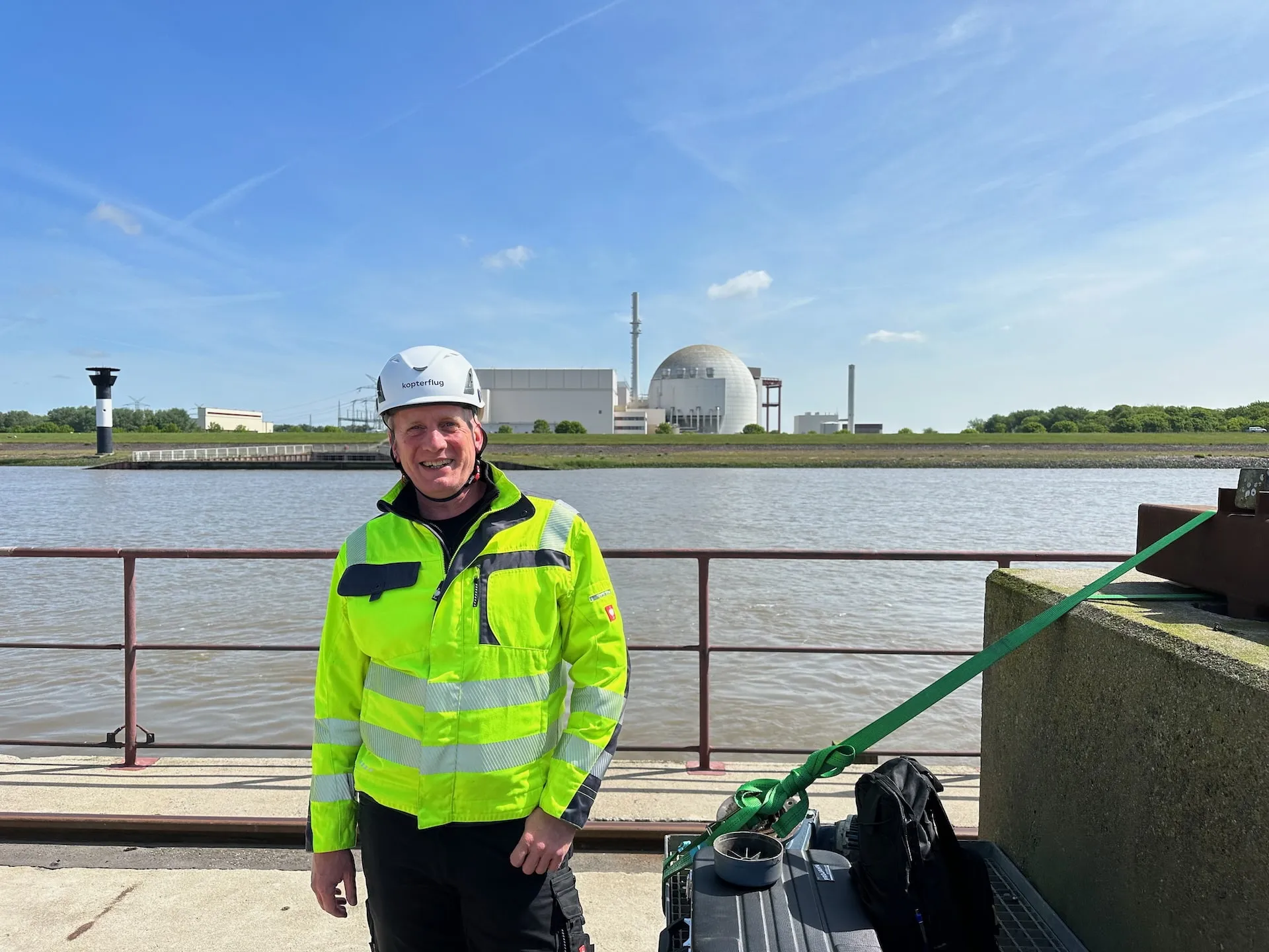
We discuss the facility, access conditions, radiation levels and approval requirements. Coordination with your radiation protection officer.
Detailed deployment concept with safety protocol. Coordination with supervisory authorities and your HSE team.
Drone inspection with ELIOS 3 – pilot remains in the safe zone. Live feed for your experts. 4K, LiDAR and thermography.
Detailed report with 4K recordings, 3D models and thermography analyses. Prepared for approval procedures and decommissioning planning.
Christian Engelke and Dipl.-Ing. Karsten Lehrke – your direct contacts for nuclear facility drone inspection projects.
Christian Engelke and Dipl.-Ing. Karsten Lehrke are your direct contacts for nuclear facility drone inspections. Since 2017, we have been operating the ELIOS 3 in demanding industrial environments – with experience in containments, ventilation ducts, cooling systems and confined spaces under challenging conditions.
We understand the specific requirements of nuclear facilities: radiation protection, approval procedures, ALARA principle, complete documentation. We advise without sales pressure – and coordinate every deployment in advance with your radiation protection officer.
Nuclear facilities near Germany where we are active for decommissioning support: Hamburg area (Krümmel / Brokdorf), Hannover area (Grohnde), Karlsruhe / KIT (Philippsburg), Mannheim and Munich area (Isar) – we support decommissioning of nuclear facilities nationwide.
Drone inspection in nuclear power plants is fundamentally possible and is used internationally in nuclear facilities – particularly for hard-to-access or radiation-exposed areas. Permissibility results from the operational release, hazard assessment and radiation protection regulations (AtG, StrlSchV). Every deployment is coordinated in advance with the radiation protection officer and responsible supervisory authorities. Confined space inspections at Kopterflug – More on nuclear applications at Flyability.
ALARA means: radiation exposure as low as reasonably achievable. Drones enable inspections without direct personnel entry into exposed areas – the pilot operates from a safe position via live feed. When no personnel enter the contaminated area, the personnel dose for that inspection task is completely eliminated. That is ALARA in practice, not just as a principle.
Yes. Drones are used in so-called hot cells, controlled areas and restricted zones where personnel entry is only possible with great effort or risk. The drone enables visual documentation and geometry capture there without exposing personnel. Deployment duration in high-dose areas is individually defined with the radiation protection officer.
Yes, decommissioning is one of the central application fields of nuclear facility drone inspection. The drone delivers pre-dismantling condition surveys, 3D capture of structures and installations, and documentation of hard-to-access areas – all without human entry into contaminated zones. The data serves as a basis for tendering, dismantling planning and approval procedures.
LiDAR generates centimetre-accurate 3D point clouds, enabling geometry capture of structures and installations, representation of cavities and wall thicknesses, and visualisation of components for dismantling planning. This creates digital twins of the facility – a well-founded planning basis that replaces or significantly reduces conventional walk-throughs. The data is usable for further evaluation in common CAD and BIM systems.
Yes, particularly for detecting thermal anomalies at plant components, leaks or insulation problems at pipeline systems, and conspicuous operating states at still-active components. Usefulness depends strongly on the boundary conditions – particularly whether a sufficient temperature difference exists between the area to be inspected and its surroundings.
Practical examples show that drone inspections can be conducted significantly faster than conventional methods involving human entry. Areas that previously required hours of walk-through with full protective equipment can be documented in minutes – at zero personnel dose. Actual duration depends on the individual case, access conditions and approval effort.
The ELIOS 3 has been tested and deployed in environments with elevated radiation exposure. Actual deployability depends on dose rate, dwell time in the area and deployment planning, and must be evaluated for each individual case. At very high dose rates, camera electronics and SLAM sensor can be affected – deployment limits are defined in advance with the radiation protection officer. Critically: even if the drone becomes contaminated, personnel remain radiation-free.
Yes. Specific RAD sensors are available for the ELIOS 3, which capture dose rates during flight and spatially reference them via SLAM position. This creates a 3D radiation map of the space – a valuable tool to identify exposed areas, plan access zones and implement the ALARA concept in a targeted manner. More on the ELIOS 3 RAD sensor.
The data – 4K video, high-resolution images and 3D models – can be an important basis for assessments, decommissioning documentation and approval procedures. Whether they are sufficient for a specific authority procedure depends on the requirements of the responsible supervisory authority and the type of procedure. We prepare data in a structured and traceable manner and support coordination with your radiation protection officer.
When no personnel enter the contaminated area, the personnel dose for that inspection task is completely eliminated. With conventional walk-throughs using protective equipment, significant personnel doses arise depending on dose rate and dwell time. The drone documents – the pilot remains in the radiation-free area. Actual dose reduction depends on which inspection tasks are replaced by drones.
Indoor drones are designed for confined environments and light wall contacts – the collision protection cage is the core design feature. Light contacts cause neither damage to the drone nor to the facility. Nevertheless, every deployment is planned with clear safety rules and abort criteria to minimise risks to the facility, environment and contamination spread.
Yes. Through documented flight paths, stored trajectories and 3D point clouds, follow-up inspections can be conducted reproducibly. In direct comparison of two inspections, condition changes – corrosion progress, structural changes, new contamination areas – are quantifiable. For a decommissioning project over many years, this is a valuable basis for continuous monitoring.
Yes, ventilation ducts, pipe tunnels and technical installations in confined areas are classic deployment fields. The drone flies through ducts from approx. 60 cm diameter, GPS-independent and with 16,000 lumens of lighting. Particularly in ventilation systems that are often hard to access and potentially contaminated, the avoidance of human entry is especially valuable.
Typical deliverables: 4K video and individual images with marked anomalies, structured inspection report with findings overview, 3D point clouds (LiDAR) and if needed thermography overlay and radiation distribution map (RAD sensor). Data is provided in a structured manner for further evaluation, approval procedures and archiving. Flyability Inspector – evaluation software.
In practice, the main limiting factors are: flight time (up to 12.5 minutes per battery – multiple flights are combined for long distances), signal connection (in very long or shielded areas the signal may weaken; repeaters or multi-segment flights help) and radiation exposure (very high dose rates can affect electronics and must be assessed in advance). For large or complex facilities, inspections are systematically divided into sections.
For pure indoor flights in buildings, a specific EU drone class (e.g. A2) is not the central factor. What matters is: experience with indoor drones in confined spaces, understanding of radiation protection and safety requirements in the nuclear environment, and coordination with the radiation protection officer and operator. We bring our own safety concept that is adapted to each facility and approval requirements.
Yes. Among the most well-known references is deployment at the Sellafield site in the UK – one of the most complex nuclear decommissioning projects worldwide. Case study: Sellafield Nuclear Site. Further published applications can be found at US DOE sites and various European decommissioning projects. We are happy to discuss our own project experience in a confidential consultation.
The economic advantage results from several factors: reduced personnel deployment in contaminated areas (less protective equipment, decontamination effort, dose accounting), no scaffolding infrastructure, shorter downtime periods and faster availability of planning bases. In decommissioning projects where personnel hours in contaminated areas generate significant costs, the drone can demonstrate ROI after just a few deployments.
This depends heavily on decommissioning progress and individual work steps. Typical: condition surveys before each new dismantling phase, accompanying checks during ongoing decommissioning work, and monitoring of critical areas for structural changes or new contamination distributions. Since drone inspections are quick to execute and involve zero personnel dose, low-threshold deployment is recommended – better to document once more than to enter the next decommissioning phase with incomplete records.
Questions about drone inspection in nuclear facilities or need a quote for your decommissioning project? Fill out the form below and we will get back to you within 24 hours.