Kopterflug deploys the ELIOS 3 with Ouster OS0-128 Surveying-Payload (surveying payload) for interior LiDAR surveys of tanks, boilers, silos and confined industrial spaces – delivering georeferenced 3D point clouds in E57/LAZ/PLY format, directly importable into your CAD and BIM software.
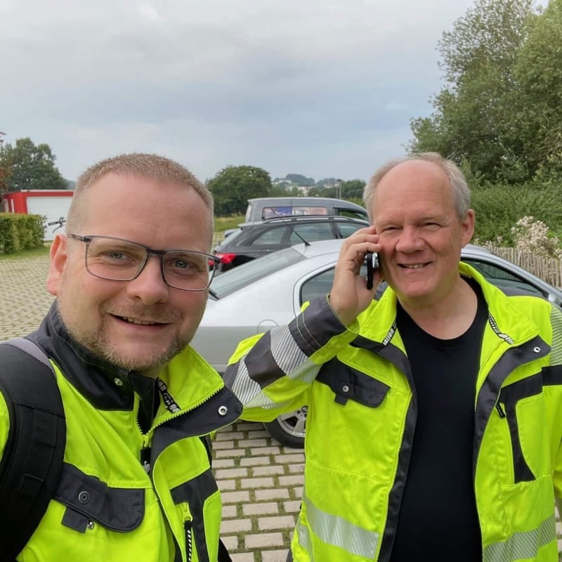
Christian Engelke and Dipl.-Ing. Karsten Lehrke – scanning industrial plant interiors since 2017.
Classical LiDAR scanners such as the Leica RTC360, Faro Focus or Trimble X12 survey everything that is reachable excellently. So do total stations and handheld devices. In real industrial plants, however, the critical section is exactly where no equipment and no person can safely go – and that is almost always the interior.
Kopterflug specializes in precisely this one area: LiDAR survey inside industrial plants – tanks, boilers, silos, reactors, fly-ash ducts, confined pipe systems and all other Confined Spaces. With the ELIOS 3 Surveying-Payload (Ouster OS0-128 Rev 6, 128 channels), high-resolution 3D point clouds are generated in the centimeter range – without scaffolding, without human entry, without shutdown.
Data is delivered in standard formats (E57, LAZ, PLY) and is directly importable into AutoCAD, Revit, BIM systems, Leica Cyclone and CloudCompare. We deliver the 3D raw data and structured findings reports – your engineers and planners work from there.
Terrestrial scanners, total stations and handheld devices survey everything that is reachable. In real industrial plants, the critical part is exactly where no equipment and no person can safely go.
Terrestrial LiDAR scanners require free lines of sight and stable setup positions. Inside tanks, boilers, silos, reactors, pipelines, bunkers or fly-ash ducts, neither exists – without expensive scaffolding, long shutdowns, hot-work permits or risky Confined-Space entry involving respiratory hazards, oxygen deficiency, fall risk and heat.
Many plants have been changed, retrofitted or deformed by corrosion and erosion incrementally over decades. Drawings, isometrics and 3D models often no longer match reality – plans for retrofit, expansion or Turnaround (planned overhaul shutdown) are based on incorrect foundations, with costly surprises on site.
Geometric deviations, ovalizations, wall thinning caused by corrosion or erosion, cracks, deformations from pressure, temperature or cyclic loading remain undetected – until they lead to leaks, failures or catastrophes. Classical methods either require shutdown with human entry or remain superficial.
High-resolution 3D data in the centimeter range from the interior of your plant – as a planning basis, as-built documentation and monitoring foundation:
ELIOS 3 Surveying Payload for interiors and confined spaces, handheld LiDAR for ground-level supplementary measurements – complete 3D model in a single appointment.
Ouster OS0-128 LiDAR: centimeter-accurate precision, 1.31 million points per second, 128 channels. GPS-free SLAM navigation in tanks, boilers, chimneys and tunnels. Real-time 3D point cloud in the cockpit. Output E57/LAZ/PLY for CAD/BIM integration.
Spontaneous deployment without tripod and without target markers. Closes ground-level gaps in the ELIOS 3 scan. Surveys pipelines, foundation points, transitions and building structures at eye level. Same E57/LAZ output for seamless point cloud fusion.
Interior and exterior scans are registered into a single combined point cloud. Result: complete 3D model of the plant building – basis for as-built documentation, conversion planning and digital twin.
E57 (standard point cloud), LAZ (compressed LAS), PLY (mesh export). Compatible with Autodesk ReCap, Leica Cyclone, CloudCompare and common CAD/BIM systems. Coordinate transformation on request.
Wherever geometry matters and classical scanners cannot reach:
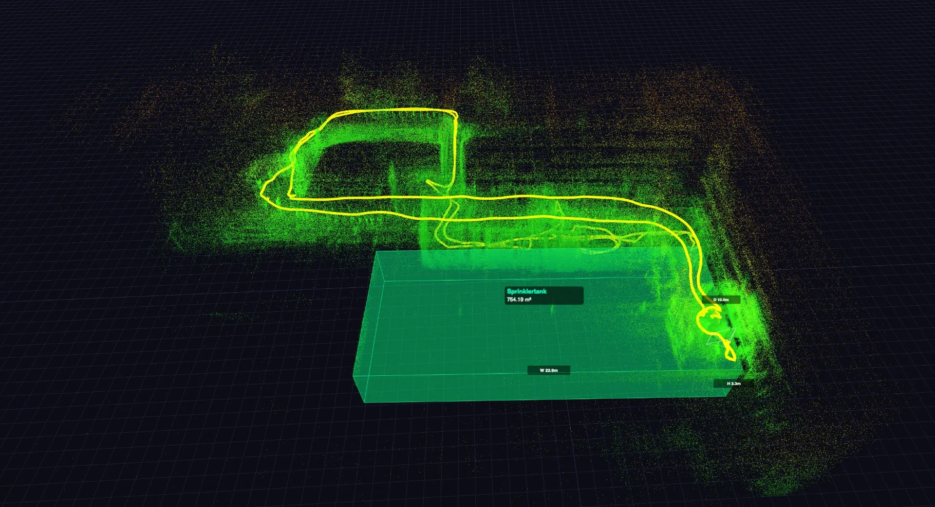
Storage tanks, process vessels, reactors. Volume calculation, ovalization check (Ovalisierungsprüfung), as-built capture after repair or conversion.
Water-tube boilers (Wasserrohrkessel), steam generators (Dampferzeuger), industrial furnaces. Interior geometry survey without scaffolding – as basis for repair planning and regulatory inspection (Normenprüfung).
Cement, grain and coal bunkers. Volume calculation for fill level management, detection of buildup (Anbackungen, i.e. material caked onto walls) and geometry changes through wear.
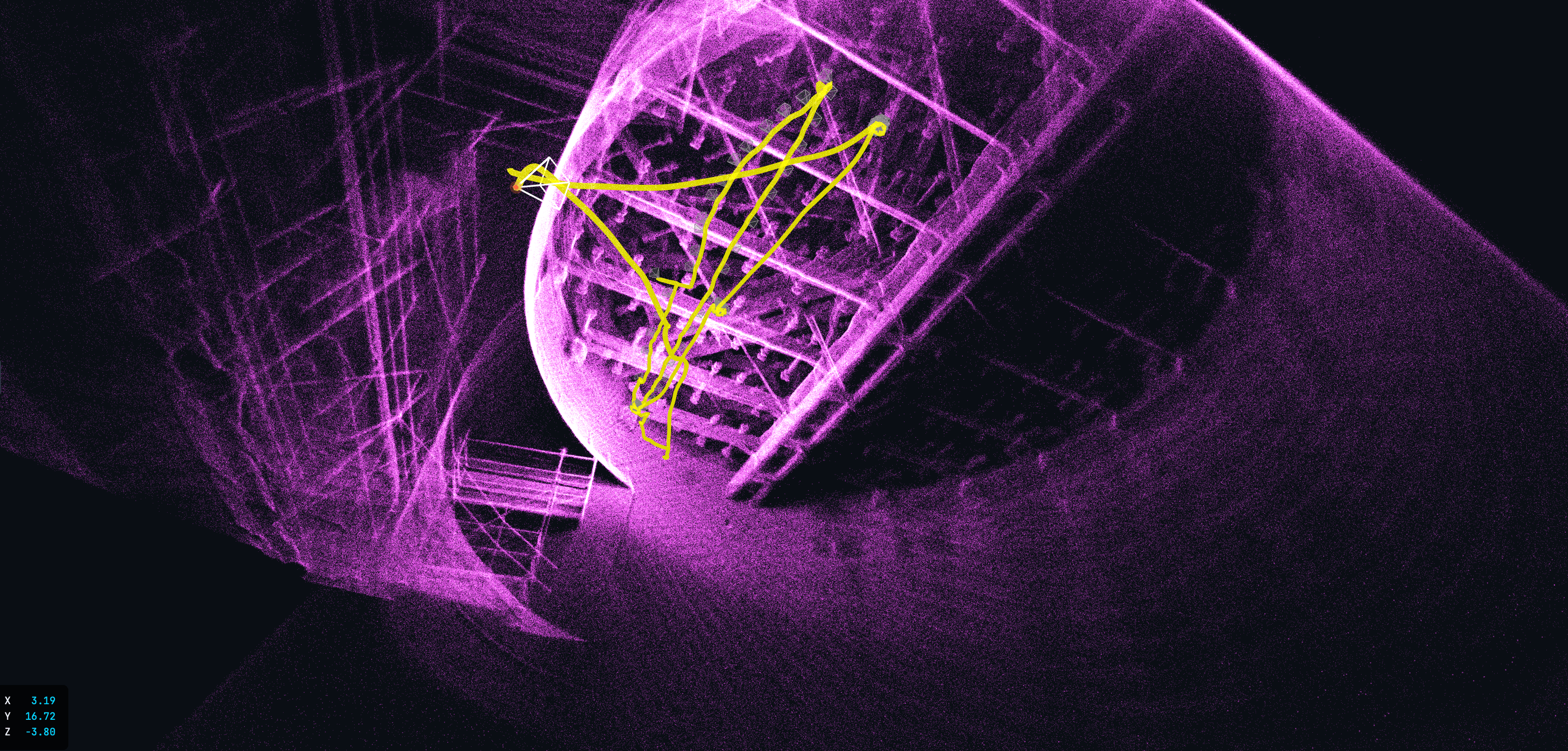
Industrial chimneys, natural-draft cooling towers. Complete 3D interior capture – wall thickness deviations, cracks geometrically located, tilt measurement (Neigungsmessung).
Large-profile ducts, pipeline sections, fly-ash ducts (Flugaschekanäle). Cross-section survey over the full length – deformations, deposit volumes and profile deviations as 3D data.
Bridge undersides, tunnel interior walls, car park ceilings. Large-area 3D capture as basis for structural inspection – cracks geometrically located, deformations measurable.
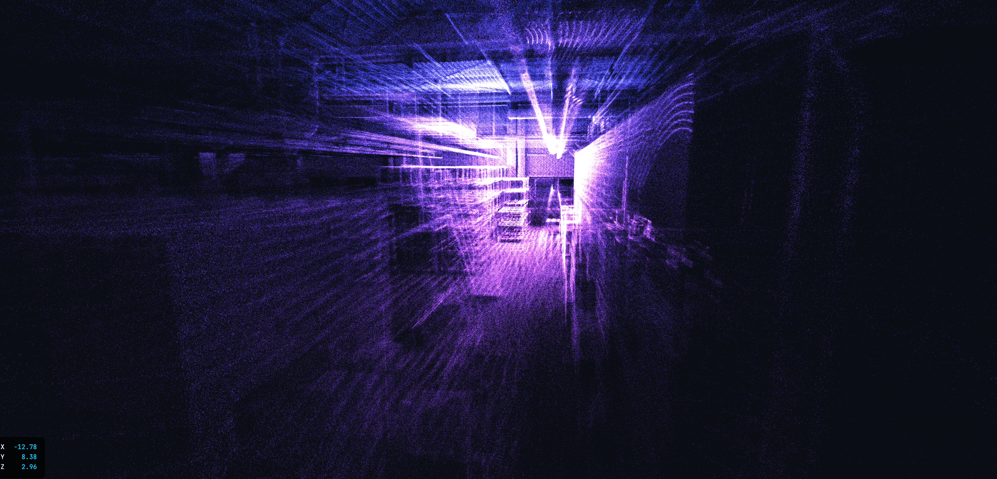
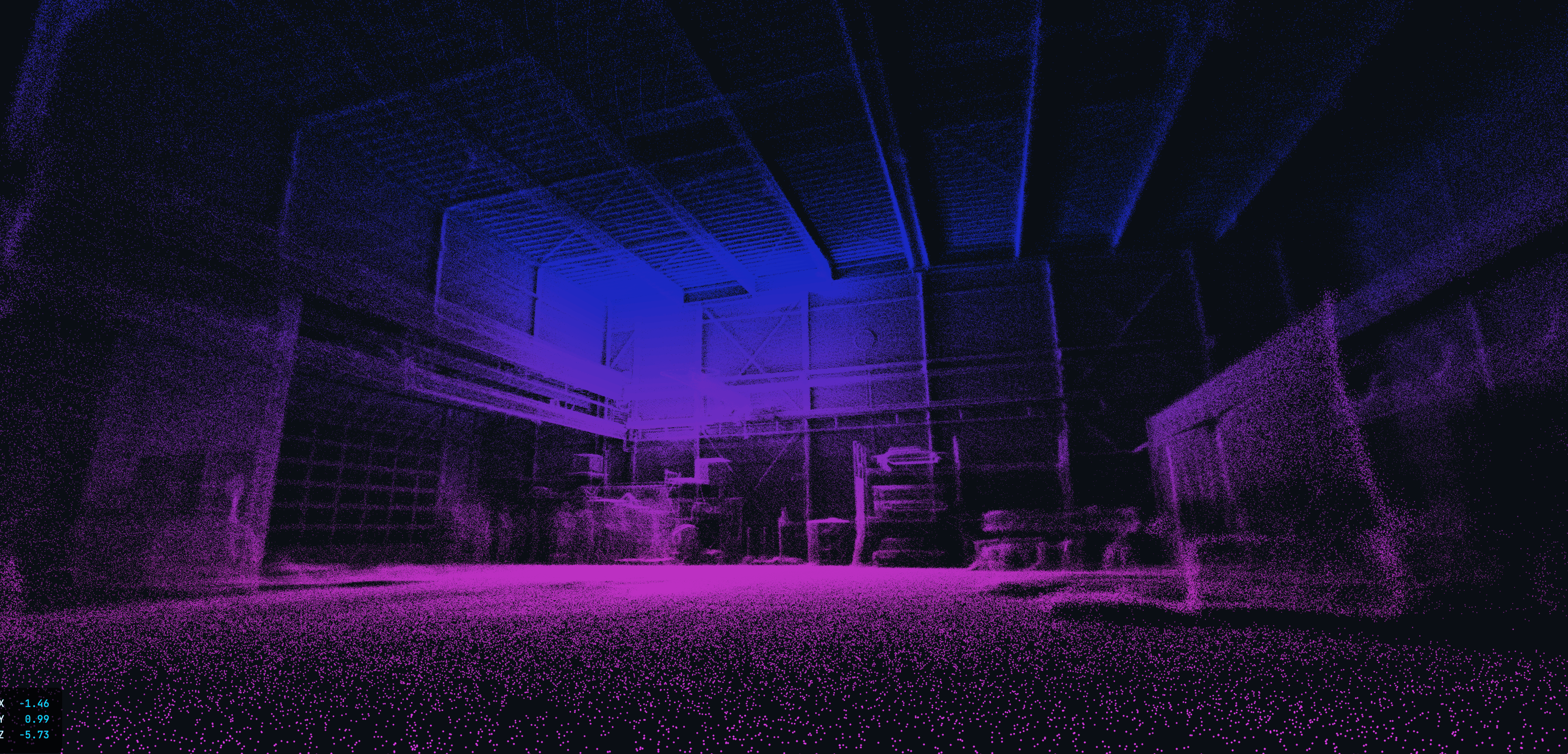
The ELIOS 3 Surveying system (Ouster OS0-128, 128 channels) creates georeferenced 3D point clouds in the centimeter range. What you receive at the end – and what your planners, inspectors and maintenance teams can do with it:
LiDAR 3D point cloud generated by the ELIOS 3 with Ouster OS0-128 – centimeter-accurate geometry data for documentation and digital twins.
Complete interior capture: walls, ceilings, floors, internals – every point georeferenced with XYZ coordinates and intensity value. Standard formats E57/LAZ are directly importable into AutoCAD, Revit, CloudCompare, Trimble Business Center and common CAD/BIM software. No proprietary formats, no data silos.
How we do it: ELIOS 3 flies with the Ouster OS0-128 (128-channel LiDAR, 360° FoV) through the interior – SLAM algorithm registers the point cloud in real time without GPS.
Actual geometry after conversion, repair, new construction or after a pressure event – as a reliable basis for release documentation and expert acceptance. Deviations between planned geometry and actual condition become measurable. Typical findings: ovalizations, wall offset after repair, geometry changes through thermal expansion over years of operation.
How we do it: Plan-to-actual comparison in the analysis system: CAD model is overlaid on the point cloud, deviations displayed color-coded – delivered to you as PDF report plus 3D model.
Interior volume of tanks, silos and vessels – even with irregular geometry, buildup or floor deposits. Fill level management based on geometrically correct volume calculations. Classical measurement methods use ideal cylinder geometry and ignore deposits, dents and internals – the LiDAR point cloud captures the actual geometry.
How we do it: 3D model is triangulated, interior volume determined by mesh calculation – accurate even with strongly irregular geometry from deposits or deformations.
Geometric changes across multiple inspection cycles: ovalization, wall thinning (indirectly via geometry change), tilts, damage progression. Reproducible flight paths and stored reference point clouds enable direct comparison between inspections. Damage progression becomes measurable – basis for condition-based maintenance (zustandsbasierte Instandhaltung) instead of calendar-based plans.
How we do it: Two point clouds (time-offset) are overlaid – deviations above 5 mm are displayed color-coded, trend is quantified.
Complete 3D model of the interior as basis for Revit modeling, plant documentation, maintenance planning and decommissioning planning. As-built records for industrial plants are frequently outdated or incomplete. The LiDAR scan delivers the actual as-is geometry – directly usable for conversion planning, tender documents and digital documentation.
How we do it: Point cloud is processed on request into a simplified 3D mesh or surface model – as a neutral handover to your CAD/BIM department or external planners.
Result: Georeferenced 3D point cloud in E57/LAZ, optional 3D mesh, volume calculation and deformation analysis – as data foundation for your planners, inspectors and maintenance teams. No human entry, no scaffolding.
| Aspect | Classical (total station / terrestrial scanner) | ELIOS 3 LiDAR Drone |
|---|---|---|
| Interior access | Scaffolding + human entry with full DGUV confined space overhead | Direct flight – no scaffolding, no entry |
| Lines of sight | Only reachable areas – internals, vessel curves, ceilings often remain blind | Complete 360° scan even behind internals and in tight spaces |
| Preparation | Scaffolding construction, gas-free measurement, entry measures – days to weeks | Coordination in hours, scan starts same day |
| Downtime | Plant must be empty, depressurized and cooled | Often possible during live operation |
| Accuracy | ±1–5 mm (equipment) – but large gaps from missing lines of sight | ±cm range (Ouster OS0-128) – complete coverage without gaps |
| Output format | E57, RCP, RCS – same planning software | E57, LAZ, PLY – directly into AutoCAD, Revit, AVEVA, BIM |
We discuss which plant sections are to be surveyed, what accuracies you need, and in what format the data should be delivered – depending on your planning software and intended use.
You receive a transparent fixed-price quotation. We coordinate the date to your revision plan or project schedule – no long lead times, no scaffolding coordination effort.
Our two-person team carries out the LiDAR scan systematically. ELIOS 3 flies all areas with the active Ouster LiDAR – simultaneously with 4K and optionally thermography. Real-time 3D map in the cockpit for quality assurance on site.
You receive the processed point cloud in the desired format, optionally with 4K texturing, thermography overlay and a structured survey report with deviation analysis – typically within a few working days after the deployment.
Christian Engelke and Dipl.-Ing. Karsten Lehrke – your direct contacts for LiDAR projects.
We have been scanning the interiors of industrial plants with the Elios since 2017 and know the requirements of planning offices, engineering firms and maintenance teams. We are not a surveying office – we deliver the 3D data, your experts work from there.
The Surveying Payload of the ELIOS 3 carries an Ouster OS0-128 Rev 6 (128 channels). Typical accuracy is in the centimeter range (1–2σ), drift <0.1 %, range up to 100 m at 80 % reflectivity. This is significantly more precise than pure navigation sensors and sufficient for as-built documentation, deformation analysis, dimensional control and most planning bases in industry. For higher accuracies (<5 mm) we recommend supplementary terrestrial reference points (Passpunkte).
Standard delivery is E57 and LAZ (compressed LAS) – compatible with AutoCAD, Revit, BIM 360, AVEVA, Leica Cyclone, CloudCompare and all common planning systems. On request also PLY, PCD or directly as a processed 3D model.
Yes – the ELIOS 3 carries LiDAR, 4K camera and thermography camera simultaneously. In a single flight, a point cloud, 4K video and thermal images are created. The thermography data can be overlaid on the point cloud – for combined geometric and thermal analysis.
Typical applications: tanks and storage vessels (volumetry, corrosion mapping, deformation), boilers, furnaces and heat exchangers, silos and bunkers (bulk goods, wall thickness), reactors and pressure vessels, pipelines and tight ducts, fly-ash and exhaust gas systems, filter houses, and tight production or storage areas with complex pipework. Essentially everywhere that classical survey equipment fails due to missing lines of sight, access restrictions or personnel safety.
LiDAR measures actively with laser pulses and works in complete darkness, in dusty atmospheres and with monotone, structure-poor surfaces (e.g. empty tanks). Photogrammetry (3D from photos) needs texture and light – often insufficient in industrial interiors. For confined spaces, LiDAR is therefore the significantly more reliable method.
Yes – on request we perform a comparison between the actual point cloud and your CAD or BIM as-built model. Deviations are marked in color and documented in a deviation report (Abweichungsbericht). This is particularly valuable after conversion work or for quality control after repairs.
Terrestrial scanners like the Leica RTC360, Faro Focus or Trimble X12 stand on the floor and scan what they can see from there – line of sight and free setup area required. In an empty tank that is still feasible, with scaffolding and significant effort. In a live or hard-to-access area, in a tight shaft, in a boiler with internals or in a fully occupied high-bay warehouse, it does not work. The ELIOS 3 flies into confined spaces no ground-based system can reach. We have been scanning interiors of vessels, boilers and shafts since 2017 – that is not a theoretical advantage but lived practice. For ground-level areas that the drone cannot reach – access routes, platform levels, foundation areas – we additionally deploy handheld walkthrough scanners: no tripod, no target points, continuous capture while walking. Both datasets are merged into a complete plant model.
Most common use cases: planning repair work where current dimensional data is missing; revision documentation (Revisionsdokumentation) after conversion work or weld repairs; reconciling as-built drawings that no longer match reality; basis for refurbishment planning and tendering; creation of revision documents for authorities and insurers. Our condition documentation service combines LiDAR with 4K imagery and a structured findings report in a single assignment.
Yes – this is one of the strongest use cases. If you have an earlier point cloud or a CAD model as reference, we can compare the current geometry against it. Bulges, wall deformations, ovalizations and deviations from nominal geometry are displayed color-coded. This is particularly relevant for pressure vessels, tanks with corrosion damage or boilers after high thermal loading. Typical accuracy in the centimeter range is sufficient for deformation analysis in most industrial applications.
No – this is an important distinction. LiDAR measures geometry: distances, shapes, deformations, spatial dimensions. Wall thickness is measured with ultrasonic wall thickness measurement (UT), not with LiDAR. If you need both – 3D geometry and wall thickness data – we can combine both in a single deployment: LiDAR scan via ELIOS 3 and UT wall thickness measurement in the same inspection run. Ask us about combined assignments.
This depends on plant size and complexity. A medium-sized tank (10–15 m diameter) is fully scanned within a few hours. A more complex plant with multiple vessels, shafts and connecting routes can take a full day. The Surveying Payload runs approx. 9 minutes per battery – our two-person team flies several sequences systematically, without long setup overhead. After the scan, data processing follows – you typically receive the processed point cloud within a few working days after the deployment.
For the LiDAR scan itself, a basic cleaning is helpful but not a prerequisite. LiDAR works significantly better than photogrammetry in dusty atmospheres and with light deposits. Strong dust clouds or highly reflective surfaces (e.g. bare metal with direct light incidence) can affect point cloud quality. We discuss the plant's current condition in advance and give an honest assessment of whether and what preparation makes sense.
There is no fundamental upper limit – we have scanned large industrial halls and extensive plants as well as tight shafts. For very large objects, multiple flight sequences are linked with reference points to generate a coherent overall point cloud. The physical lower limit is openings below approx. 50 × 50 cm – that is where the ELIOS 3 can no longer pass through.
As standard we work with relative georeferencing: the point cloud is internally consistent and to scale, but not tied to an absolute coordinate system. If you need absolute georeferencing (e.g. for BIM projects or site plan integration), we set terrestrial reference points (Passpunkte) in advance or use your existing survey points as reference. This must be clarified beforehand so we set the right reference points.
Yes – silos and bulk storage bunkers are an ideal use case. LiDAR captures the bulk material surface and calculates the volume from it – significantly faster and safer than manual volume determination. At the same time, the silo interior wall is documented for deformations, crack formation and material detachment. This is lived practice from our projects since 2017.
A digital twin in our context means: the point cloud of your plant, textured with 4K image data, optionally supplemented by thermography overlay and structured findings report – all together as a navigable 3D foundation. This is the data basis with which your planners, maintenance teams and purchasers can access the plant remotely. We deliver the raw data and processed exports – the further development into a fully integrated asset management system rests with your team.
Yes – and this is a particularly effective combination. In a single deployment, the ELIOS 3 delivers LiDAR geometry data for as-built documentation and deformation analysis, while we simultaneously or subsequently carry out ultrasonic wall thickness measurement (UT) at critical points. This gives you geometric overall structure plus point-specific material data from a single appointment. Particularly relevant for tank floors and shells (Tankböden und -mäntel) and boiler walls with suspected corrosion.
Yes – E57, LAZ and PLY are open standards processed by all common programs: AutoCAD, Revit, AVEVA, Bentley, CloudCompare, Leica Cyclone, ReCap, Trimble RealWorks. You do not need any proprietary software from us. If your team has not yet worked with point cloud data, we recommend CloudCompare as a free entry point. We provide guidance on further processing as needed.
Significantly faster than classical survey projects. No scaffolding, no long lead times for safety measures, no external coordination with scaffolding contractors. If your plant is accessible to us, we can typically be on site within a few working days. For revision windows (Revisionsfenster) or shutdown planning we recommend early scheduling – but in emergencies we can also be deployed reactively.
Yes. Ground-level structures, pipeline levels, maintenance platforms and access routes are often not approachable for the ELIOS 3. For these areas we deploy handheld LiDAR scanners (walkthrough systems): the technician walks through the area, the scanner captures continuously – no tripod, no preparation. The handheld point cloud is in the same format (E57/LAZ) as the drone data and is seamlessly merged. The result is a gap-free 3D capture of the entire plant.
Yes. Both the ELIOS 3 LiDAR and handheld walkthrough scanners start without preparation. If an unplanned measurement need arises during an inspection – a distance measurement, a dimensional survey for a repair, an unexpected deformation – a complete scan can be taken directly on site. All dimensions are then readable from the point cloud without returning to the plant.
A LiDAR scan makes sense when you need to document dimensions, geometries or deformations – i.e. as-built data for planning, deformation analysis of pressure vessels, volume determination in silos or comparison against CAD models. A pure 4K inspection is sufficient when the goal is visual condition capture – corrosion, coating damage, cracks – without dimensional requirements. In many deployments we combine both in a single flight, as the additional effort is small. Our recommendation: in the free initial consultation we clarify together which data package meets your requirements.
Yes – our point clouds and structured survey reports are regularly used as basis for TÜV, DEKRA, experts and insurance assessments. The data is traceable, reproducible and documented in standard formats (E57, LAZ). For official documentation of überwachungsbedürftige Anlagen (plants subject to mandatory supervision) under BetrSichV (German Industrial Safety Regulation, Betriebssicherheitsverordnung), we recommend aligning requirements with your inspection organization in advance – acceptance depends on the inspector and the specific intended use.
Have questions about industrial LiDAR survey or need a quote for your project? Fill out the form below and we will get back to you within 24 hours.