Kopterflug inspects bridges, tunnels, car parks, retaining walls and traffic structures without scaffolding, without closures and without human entry into hazardous areas – with the Flyability ELIOS 3, DJI M30T and handheld LiDAR. GPS-free, collision-safe, 4K + LiDAR + thermography.
Bridges, tunnels, car parks and retaining walls – difficult to access, high inspection effort, safety-critical. We inspect all relevant structures without scaffolding, without closures and without human entry into hazardous areas:
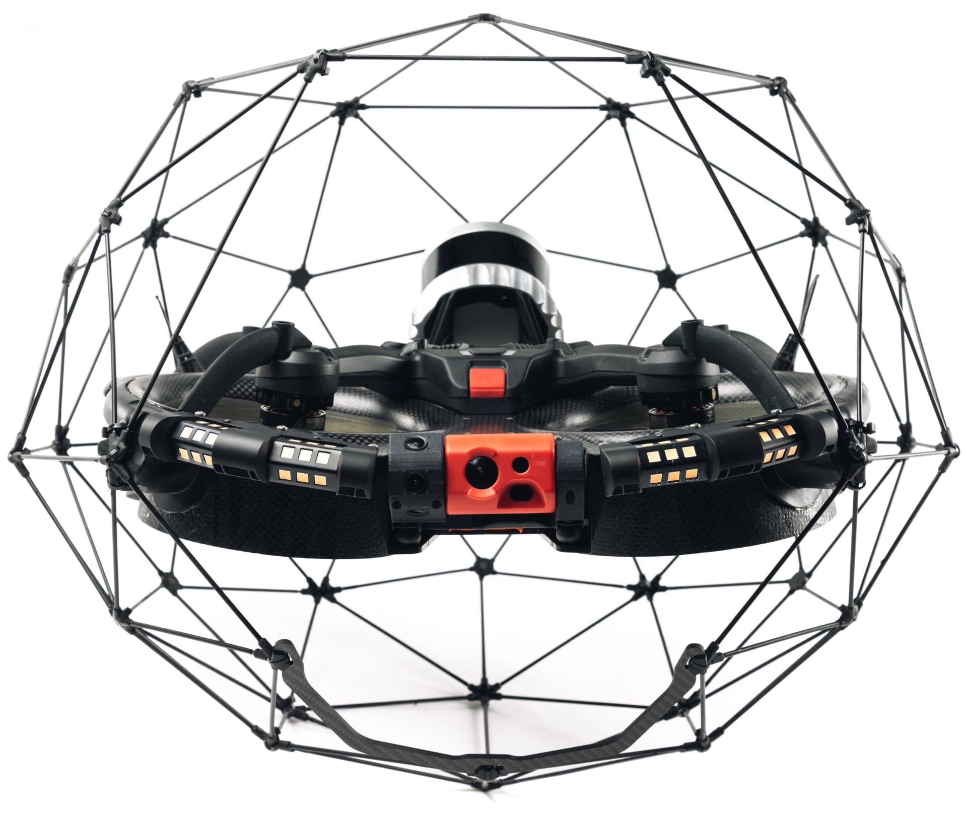
Bridges, tunnels, car parks – high hazard, elaborate access equipment, long closures. Conventional methods are expensive, slow and disruptive. The ELIOS 3 solves this – without scaffolding and without closure.
Depending on the structure, we deploy ELIOS 3 (interior/confined areas), DJI M30T (exterior/thermal) or both combined – without scaffolding, without closure.
Inspection of substructures, main beams, hangers, bearings and waterproofing. LiDAR captures geometry and deformations. Thermography shows moisture ingress and voids.
Recording of vault damage, cracks, spalling, joint openings and drainage failures. LiDAR maps the complete tunnel cross-section.
Testing of reinforced concrete decks, columns and walls for cracks, reinforcement corrosion and chloride attack. Thermography shows voids and moisture.
Condition assessment of difficult-to-access wall surfaces, joints, drainage openings and connection areas. LiDAR measures deformations and inclinations.
Inspection of superstructures, cross-beams, bearing areas and overhead line proximity – without track closure. Focus on difficult-to-access areas beneath the track bed.
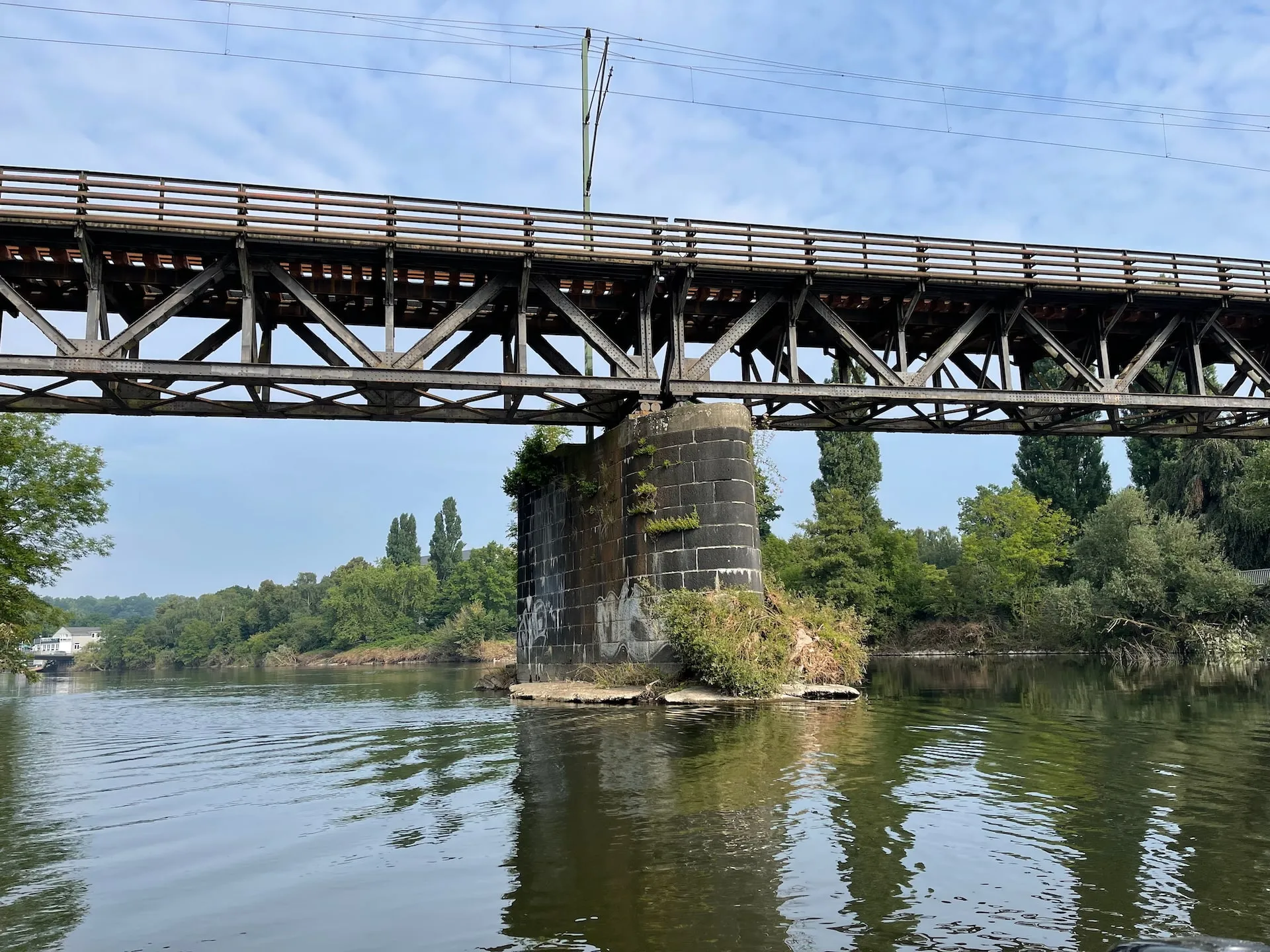
Inspection of bridge soffits, cantilevers, parapets and drainage systems – without traffic closure.
Inspection of culverts under roads and rail lines – often difficult to access and regularly requiring inspection. For water-bearing culverts, supplemented by ROV.
Bridge piers, foundation structures and abutments below water without divers – ROV inspection with 4K camera. Scour, reinforcement corrosion, coating damage and structural damage below the waterline completely documented.
We analyse your structure and advise you free of charge on feasibility, sensors, access point and coordination with road traffic authorities or operators.
You receive a transparent quotation. Together we plan the timing, any reduced closure periods and the safety concept.
We carry out the inspection with ELIOS 3 – usually within a few hours, without elaborate access infrastructure.
You receive a detailed report with 4K recordings, LiDAR 3D models, thermography analyses and systematic findings overview – as the basis for structure inspectors or experts.
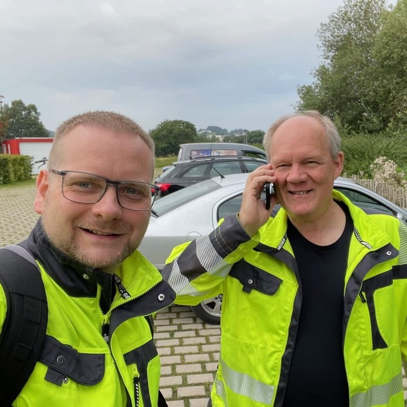
Christian Engelke and Dipl.-Ing. Karsten Lehrke – your direct contacts for infrastructure inspection projects.
Since 2017 we have been inspecting engineering structures, bridges, tunnels and car parks – numerous inspections of demanding infrastructure structures with ELIOS 3, LiDAR and thermography. We understand the specific requirements: documentation quality and minimal operational disruption.
We advise without sales pressure – openly and honestly about what makes sense for your structure.
Not completely, but it is a valuable supplement. The main inspection per DIN 1076 requires qualified structure inspectors and may require contact testing (e.g. crack width measurement). The drone delivers high-quality 4K images and LiDAR 3D data from difficult-to-access areas that serve inspectors as a decision basis – and often replace elaborate access infrastructure. Routine inspections per DIN 1076 can use the drone as the primary recording instrument.
We inspect steel bridges, concrete bridges, composite bridges and pipe bridges – from simple culverts to large motorway bridges. Particularly suitable: bridges with difficult-to-access soffits, suspension bridges with hangers, and pipe bridges over waterways and roads where scaffolding or elevated platforms would be very costly.
Yes – and this is one of the main applications of the ELIOS 3. The drone navigates GPS-independently via SLAM and flies through road tunnels, rail tunnels, pedestrian underpasses and pipe tunnels. LiDAR maps the complete cross-section, 4K documents vault damage, cracks and efflorescence. Deployment at reduced or closed operation.
This depends on the tunnel type and operator. For road tunnels a partial closure or night inspection is generally required – but significantly shorter than with conventional methods. Service and pedestrian tunnels can often be inspected without closure. We advise on the optimal solution for your specific case.
LiDAR creates complete 3D point clouds of structure geometries – tunnel cross-sections, bridge beams and wall surfaces. This enables: deformation analysis and deformation measurement, comparison between inspection cycles, detection of geometry changes, and the basis for digital twins and BIM models.
Yes, as a valuable supplement. Thermography shows moisture ingress, voids behind concrete layers and temperature anomalies. On bridges, bearings and waterproofing areas can be thermally assessed. Thermography is an indicative method – it provides indications for further testing but does not replace normative non-destructive contact testing.
You receive: 4K recordings of all documented areas with systematic findings capture, LiDAR 3D point clouds for geometry measurement and deformation analyses, thermographic recordings as required, and a structured inspection report as the basis for your structure inspectors or experts.
Yes. Car parks are a typical application: reinforced concrete decks, columns and ramps can be examined without scaffolding. Thermography shows moisture ingress and voids. The drone navigates collision-safely under low ceilings and between vehicles. Particularly useful for regular condition monitoring after remediation work.
Typical findings: concrete cracks and spalling, carbonation and chloride attack on reinforced concrete structures, corrosion on steel frames and hangers, coating damage, joint damage and water ingress, reinforcement corrosion (detectable by rust streaks and spalling), and bearing deformations and failures.
Yes. Retaining walls and noise barriers often have difficult-to-access areas – high wall surfaces, slopes, connection areas. The drone flies along the wall and documents cracks, joint damage, efflorescence and tilting. LiDAR can measure inclinations and deformations – without scaffolding, without elaborate access equipment.
Duration depends on the size and complexity of the structure. A bridge soffit or simple tunnel is typically inspected in 4–8 hours. Car park floors are captured in 2–4 hours depending on size. Larger tunnels or extensive bridge structures are planned in daily stages. We give you a concrete timeframe in the quotation.
In many cases yes – the drone flies under bridges, through tunnels and under car park decks without scaffolding, elevated platforms or under-bridge inspection vehicles needing to be erected. For contact testing (e.g. hammer sounding or crack width measurement), supplementary manual work may be required. For comprehensive visual documentation and LiDAR survey, the drone is the more cost-effective and safer method.
Yes. The LiDAR survey delivers georeferenced 3D point clouds – every finding is precisely located in space and can be directly re-found in follow-up inspections. 4K recordings are systematically captured and referenced in the inspection report. This enables precise damage localisation and direct comparison between inspection cycles.
Rope access and industrial climbers require anchor points, permits and are limited to individual areas. The drone captures large surfaces in a short time – without human entry and without fall risk. While a climber documents a few hundred square metres per day, the drone achieves a multiple of that. For contact-based testing, rope access remains a useful complement, but for comprehensive visual documentation the drone is significantly more efficient.
Yes. The DJI Matrice 30T documents facade surfaces with 4K resolution and 200x zoom – even fine cracks, plaster damage and joint leaks are captured from a safe distance. Radiometric thermography reveals thermal bridges, moisture and waterproofing defects in the facade. Scaffolding or aerial platforms are eliminated in most cases.
Exterior inspections with the DJI Matrice 30T are possible at wind speeds up to 12 m/s and light rain. The ELIOS 3 flies in sheltered interiors (tunnels, box girders, car parks) regardless of weather. For thermography on facades we recommend dry conditions and minimal solar radiation to obtain meaningful thermal images. We coordinate the deployment date accordingly.
Our report is aligned with the requirements of DIN 1076 and the RI-EBW-PRÜF for bridge inspections. You receive a systematic findings list with damage classification, georeferenced 4K image evidence, LiDAR 3D models and an overview map of all finding locations. The report is structured so your structural engineers and experts can work directly with it.
Yes. The LiDAR point clouds can be imported directly into standard BIM software (Autodesk Revit, Bentley, Trimble). The 3D data serve as the basis for digital twins of bridges, tunnels and buildings. This allows inspection findings to be spatially located, refurbishment plans to be visualised and condition changes to be compared across multiple inspection cycles.
Generally yes. For deployments on federal highways, railway structures and public infrastructure, permits from the relevant authorities (e.g. road traffic authority, Federal Railway Authority) and potentially aviation permits are required. We hold all necessary operating permits and handle the complete coordination with the authorities – you receive a turnkey deployment.
Safety is our highest priority. The ELIOS 3 flies within its protective cage and is secured against contact with structural elements. For exterior inspections we prepare a safety concept with barriers, safety distances and fallback scenarios. Our pilots are certified under EU drone regulation and have extensive deployment experience at transport infrastructure.
DIN 1076 mandates a major inspection every 6 years and a simple inspection every 3 years for bridges. For car park decks and underground garages we recommend inspection every 2–5 years depending on loading. In general: the earlier damage is detected, the lower the repair costs. The drone makes more frequent inspection intervals economically viable.
Costs depend on structure size, accessibility and required documentation scope. Typical deployments for individual bridges or tunnel sections start in the low four-figure range. Compared to scaffolding, aerial platform hire or under-bridge units, you typically save 40–70 % on access costs. We provide an individual quote following a brief phone consultation.
Questions about drone inspection for infrastructure or need a quote? Fill out the form and we'll get back to you within 24 hours.